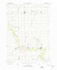
1957 Map of Potomac
USGS Topo · Published 1958About this map
Potomac and the surrounding agricultural townships of east-central Illinois are documented here during the mid-1950s, a period of transition as traditional one-room schoolhouses like the Science Hill Sch were already falling out of use. The landscape is defined by the meandering courses of the Vermilion River and Bluegrass Creek, which contrast with the rigid sectional grid of the surrounding prairie. Transportation is anchored by the New York Chicago and St Louis and the Illinois Central and Chicago Eastern railroads, which facilitated the grain and livestock trade for small settlements like Rankin and Armstrong. Numerous local burial grounds, including Chenoweth Cem and St Lawrence Cem, provide essential data for genealogical research, pinpointing early family plots and community centers like Wallace Chapel that were often located at remote crossroads.
Find a feature on this map
58 named features on this map. Tap any name to fly to it.
Don’t see what you’re looking for? This feature index may not catch every label — zoom into the map to look around manually.
Map Details
Editions of this 1957 Potomac Map
2 editions found
Other maps of this area

1899 · Danville
USGS Topo · 1:62,500

1900 · Danville
USGS Topo · 1:62,500

1906 · Urbana
USGS Topo · 1:62,500

1924 · Paxton
USGS Topo · 1:62,500

1927 · Paxton
USGS Topo · 1:62,500

1931 · Fithian
USGS Topo · 1:48,000

1933 · Hoopeston
USGS Topo · 1:48,000

1936 · Potomac
USGS Topo · 1:62,500

1938 · Milford
USGS Topo · 1:48,000

1938 · Hoopeston
USGS Topo · 1:62,500