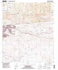
1996 Map of Potrero
USGS Topo · Published 2002About this map
Potrero sits at the northern end of this international landscape, where the high-elevation valleys of Hauser Mountain meet the international border. This mid-1990s survey illustrates a rural-industrial borderland defined by trans-boundary utility and communication lines, including a significant pipeline and a telephone line corridor. While the California side is marked by the rugged path of the Pacific Crest National Scenic Trail and the small communities of Canyon City and Division, the landscape transitions south into the Mexican state of Baja California. Here, the settlement pattern is characterized by numerous small establos and ranchos such as Establo la Paleta and Los Villarreal, situated among the deep drainages of Arroyo Seco and Cañada Joe Bill. The infrastructure supporting the city of Tecate is visible, including the C. La Panocha TV Tower and various water systems.
Find a feature on this map
78 named features on this map. Tap any name to fly to it.
Don’t see what you’re looking for? This feature index may not catch every label — zoom into the map to look around manually.
Map Details
Editions of this 1996 Potrero Map
This is the sole edition of this map. No revisions or reprints were ever made.
Other maps of this area

1903 · Cuyamaca
USGS Topo · 1:125,000

1904 · Southern California Sheet No. 2
USGS Topo · 1:250,000

1931 · Carrizo
USGS Topo · 1:125,000

1939 · Campo
USGS Topo · 1:62,500

1942 · Potrero
USGS Topo · 1:48,000

1942 · Campo
USGS Topo · 1:62,500

1944 · Potrero
USGS Topo · 1:62,500

1950 · San Diego
USGS Topo · 1:250,000

1954 · San Diego
USGS Topo · 1:250,000

1955 · San Diego
USGS Topo · 1:250,000