
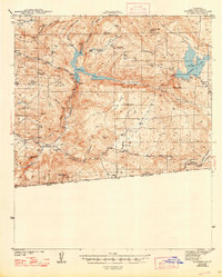
1944 Map of Potrero
USGS Topo · Published 1944About this map
The international border between the United States and Mexico defines the southern edge of this 1942 survey, where the Custom House at Tecate stands as a primary crossing point. Inland, the landscape is shaped by the water management systems of the era, notably the vast reservoirs of Barrett Lake and Morena Lake connected by Cottonwood Creek. Small agricultural and transit nodes like Potrero and Barrett Junction serve as local centers, providing essential services through the Potrero School and Barrett School.
Find a feature on this map
39 named features on this map. Tap any name to fly to it.
Don’t see what you’re looking for? This feature index may not catch every label — zoom into the map to look around manually.
Map Details
Editions of this 1944 Potrero Map
2 editions found
Other maps of this area

1893 · El Cajon
USGS Topo · 1:62,500

1901 · Elcajon
USGS Topo · 1:62,500

1903 · Cuyamaca
USGS Topo · 1:125,000

1903 · Elcajon
USGS Topo · 1:62,500

1904 · Southern California Sheet No. 2
USGS Topo · 1:250,000

1931 · Carrizo
USGS Topo · 1:125,000

1939 · El Cajon
USGS Topo · 1:62,500

1939 · Campo
USGS Topo · 1:62,500

1942 · Potrero
USGS Topo · 1:48,000

1942 · El Cajon
USGS Topo · 1:62,500