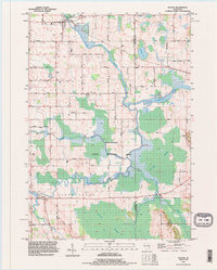
1993 Map of Potter
USGS Topo · Published 1996About this map
The North Branch Manitowoc River and the South Branch Manitowoc River converge in this corner of Calumet County, creating a landscape defined by extensive wetlands and conservation lands. The Killsnake State Wildlife Area and Hayton Marsh dominate the central and southern portions of the map, illustrating the preservation of large-scale marshlands in eastern Wisconsin during the late 20th century.
Find a feature on this map
44 named features on this map. Tap any name to fly to it.
Don’t see what you’re looking for? This feature index may not catch every label — zoom into the map to look around manually.
Map Details
Editions of this 1993 Potter Map
This is the sole edition of this map. No revisions or reprints were ever made.
Other maps of this area

1954 · School Hill
USGS Topo · 1:24,000

1954 · Howards Grove
USGS Topo · 1:62,500

1954 · Chilton
USGS Topo · 1:62,500

1954 · Reedsville
USGS Topo · 1:62,500

1954 · Kiel
USGS Topo · 1:62,500

1954 · Milwaukee
USGS Topo · 1:250,000

1954 · Manitowoc
USGS Topo · 1:250,000

1955 · Green Bay
USGS Topo · 1:250,000

1957 · Madison
USGS Topo · 1:250,000

1958 · Manitowoc
USGS Topo · 1:250,000