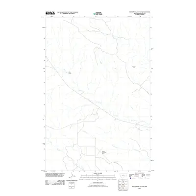
2011 Map of Poverty Flat East
USGS Topo · Published 2011About this map
Dawson Community Airport sits as a primary landmark in this drainage-heavy portion of Dawson County, located just northwest of the Yellowstone River corridor. The landscape is defined by the dendritic patterns of Deer Creek, Crisafulli Creek, and Dry Creek, which carve through the plains toward the river valley. To the northeast, the elevation rises toward Glendive Butte, a prominent local topographic feature. The network of rural routes, including Fas 254 and Dry Creek Rd, connects isolated ranches and grazing lands. Named features like D Bar Coulee indicate the area's long-standing ranching heritage, where specific coulees and draws were named for navigation and property identification in a region where water sources and natural shelter are critical to the local economy.
Find a feature on this map
9 named features on this map. Tap any name to fly to it.
Don’t see what you’re looking for? This feature index may not catch every label — zoom into the map to look around manually.
Map Details
Editions of this 2011 Poverty Flat East Map
This is the sole edition of this map. No revisions or reprints were ever made.
Other maps of this area

1909 · Glendive
USGS Topo · 1:250,000

1954 · Glendive
USGS Topo · 1:250,000

1957 · Glendive
USGS Topo · 1:250,000

1958 · Glendive
USGS Topo · 1:250,000

1966 · Kolberg Ranch
USGS Topo · 1:24,000

1967 · Stipek
USGS Topo · 1:24,000
1967 · Glendive
USGS Topo · 1:24,000
1967 · Forest Park
USGS Topo · 1:24,000

1972 · Morgan Creek School
USGS Topo · 1:24,000
1972 · Pleasant View
USGS Topo · 1:24,000