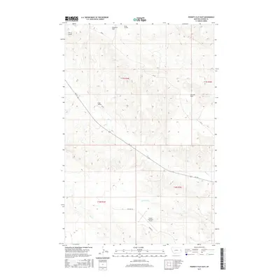
2017 Map of Poverty Flat East
USGS Topo · Published 2017About this map
Glendive Butte and the broad elevated terrain of Threemile Table define the landscape of Dawson County in this section of eastern Montana. The map illustrates a high-plains environment deeply etched by drainage systems, including Cherry Coulee, Plum Coulee, and D Bar Coulee. These watercourses flow toward larger arteries like Deer Cr and Crisafulli Cr, which wind through the township grids. A critical piece of regional infrastructure, the Dawson Community Airport, is situated in the southern portion of the sheet, served by Airport Rd. The transport network is characterized by remote thoroughfares such as Fas 254 and RD 550, which facilitate movement across the cattle country and dryland agricultural plots that dominate the local economy.
Find a feature on this map
17 named features on this map. Tap any name to fly to it.
Don’t see what you’re looking for? This feature index may not catch every label — zoom into the map to look around manually.
Map Details
Editions of this 2017 Poverty Flat East Map
This is the sole edition of this map. No revisions or reprints were ever made.
Other maps of this area

1909 · Glendive
USGS Topo · 1:250,000

1954 · Glendive
USGS Topo · 1:250,000

1957 · Glendive
USGS Topo · 1:250,000

1958 · Glendive
USGS Topo · 1:250,000

1966 · Kolberg Ranch
USGS Topo · 1:24,000

1967 · Stipek
USGS Topo · 1:24,000
1967 · Glendive
USGS Topo · 1:24,000
1967 · Forest Park
USGS Topo · 1:24,000

1972 · Morgan Creek School
USGS Topo · 1:24,000
1972 · Pleasant View
USGS Topo · 1:24,000