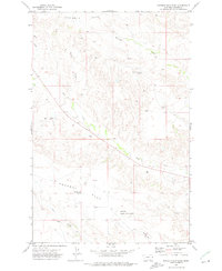
1972 Map of Poverty Flat East
USGS Topo · Published 1975About this map
Poverty Flat and the surrounding high plains of Dawson County are documented here in the early 1970s, revealing a landscape defined by isolated rural infrastructure and seasonal drainage systems. The presence of the Lower Threemile School and Poverty Flat School indicates a decentralized educational network serving the ranching families of the era. The terrain is structured by prominent tablelands like Threemile Table and deep-cut coulees such as Cherry Coulee, which channel water toward Threemile Creek and Deer Creek. Aviation and local industry are represented by the Dawson Community Airport in the south and the Garnost Mine further west. This survey illustrates the spatial distribution of homestead-era relics and active 20th-century resource extraction, showing how topographical features like Dry Creek and Fourmile Hill dictated the placement of roads and gravel operations.
Find a feature on this map
14 named features on this map. Tap any name to fly to it.
Don’t see what you’re looking for? This feature index may not catch every label — zoom into the map to look around manually.
Map Details
Editions of this 1972 Poverty Flat East Map
This is the sole edition of this map. No revisions or reprints were ever made.
Other maps of this area

1909 · Glendive
USGS Topo · 1:250,000

1954 · Glendive
USGS Topo · 1:250,000

1957 · Glendive
USGS Topo · 1:250,000

1958 · Glendive
USGS Topo · 1:250,000

1966 · Kolberg Ranch
USGS Topo · 1:24,000

1967 · Stipek
USGS Topo · 1:24,000
1967 · Glendive
USGS Topo · 1:24,000
1967 · Forest Park
USGS Topo · 1:24,000

1972 · Morgan Creek School
USGS Topo · 1:24,000
1972 · Pleasant View
USGS Topo · 1:24,000