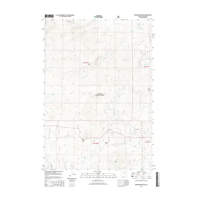
2015 Map of Powder River Pass
USGS Topo · Published 2015About this map
Bighorn National Forest defines this high-altitude landscape in Johnson County, where the southern Big Horn Mountains reach significant elevations at Loaf Mtn and Sheep Mtn. The hydrology of the area is complex, characterized by the headwaters of the N Fork Powder River and N Fork Crazy Woman Cr, which flow from glacial basins such as those containing Paradise Lake and Magdalene Lake. Transportation through this steep terrain is anchored by the crossing at Powder River Pass, with secondary access provided by Pole Creek Rd and the evocatively named Gold Mine Rd. This 2015 survey illustrates how modern infrastructure follows the natural corridors established by Munkres Pass and various creek drainages including E Tensleep Cr and Duck Cr, maintaining the historic routes used to traverse these Wyoming highlands.
Find a feature on this map
32 named features on this map. Tap any name to fly to it.
Don’t see what you’re looking for? This feature index may not catch every label — zoom into the map to look around manually.
Map Details
Editions of this 2015 Powder River Pass Map
This is the sole edition of this map. No revisions or reprints were ever made.
Other maps of this area

1899 · Cloud peak
USGS Topo · 1:125,000

1900 · Fort McKinney
USGS Topo · 1:125,000

1901 · Cloud Peak
USGS Topo · 1:125,000

1903 · Fort McKinney
USGS Topo · 1:125,000

1955 · Sheridan
USGS Topo · 1:250,000

1958 · Sheridan
USGS Topo · 1:250,000

1962 · Sheridan
USGS Topo · 1:250,000
1967 · Onion Gulch
USGS Topo · 1:24,000

1967 · Caribou Creek
USGS Topo · 1:24,000
1967 · Hazelton
USGS Topo · 1:24,000