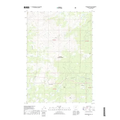
2017 Map of Powder River Pass
USGS Topo · Published 2017About this map
Bighorn National Forest dominates this high-altitude topography of the Big Horn Mountains, where the continental divide is marked by significant crossings like Powder River Pass and Munkres Pass. The landscape is a network of alpine hydrology, feeding the headwaters of the N Fork Powder River and the curiously named N Fork Crazy Woman Creek. High peaks such as Loaf Mtn and Hesse Mtn rise above a series of glacial lakes, including Firehole Lakes, Paradise Lake, and Brown Bear Lake.
Find a feature on this map
34 named features on this map. Tap any name to fly to it.
Don’t see what you’re looking for? This feature index may not catch every label — zoom into the map to look around manually.
Map Details
Editions of this 2017 Powder River Pass Map
This is the sole edition of this map. No revisions or reprints were ever made.
Other maps of this area

1899 · Cloud peak
USGS Topo · 1:125,000

1900 · Fort McKinney
USGS Topo · 1:125,000

1901 · Cloud Peak
USGS Topo · 1:125,000

1903 · Fort McKinney
USGS Topo · 1:125,000

1955 · Sheridan
USGS Topo · 1:250,000

1958 · Sheridan
USGS Topo · 1:250,000

1962 · Sheridan
USGS Topo · 1:250,000
1967 · Onion Gulch
USGS Topo · 1:24,000

1967 · Caribou Creek
USGS Topo · 1:24,000
1967 · Hazelton
USGS Topo · 1:24,000