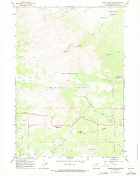
1967 Map of Powder River Pass
USGS Topo · Published 1971About this map
Powder River Pass serves as the central high-altitude crossing in this 1960s survey of the Johnson County high country. Located within the Bighorn National Forest, the terrain is defined by extreme elevations and the headwaters of numerous divergent drainage systems. Notable peaks such as Loaf Mountain and Hesse Mountain overlook a complex network of alpine water bodies, including Firehole Lakes, Paradise Lake, and Magdalene Lake. The map illustrates the early infrastructure of Route 16 as it winds through the pass, providing a crucial link across the Bighorn range. This topography highlights the hydrological importance of the area, showing the origins of the North Fork Powder River and North Fork Crazy Woman Creek, alongside smaller streams like Sourdough Creek and Baby Wagon Creek.
Find a feature on this map
26 named features on this map. Tap any name to fly to it.
Don’t see what you’re looking for? This feature index may not catch every label — zoom into the map to look around manually.
Map Details
Editions of this 1967 Powder River Pass Map
This is the sole edition of this map. No revisions or reprints were ever made.
Other maps of this area

1899 · Cloud peak
USGS Topo · 1:125,000

1900 · Fort McKinney
USGS Topo · 1:125,000

1901 · Cloud Peak
USGS Topo · 1:125,000

1903 · Fort McKinney
USGS Topo · 1:125,000

1955 · Sheridan
USGS Topo · 1:250,000

1958 · Sheridan
USGS Topo · 1:250,000

1962 · Sheridan
USGS Topo · 1:250,000
1967 · Onion Gulch
USGS Topo · 1:24,000

1967 · Caribou Creek
USGS Topo · 1:24,000
1967 · Hazelton
USGS Topo · 1:24,000