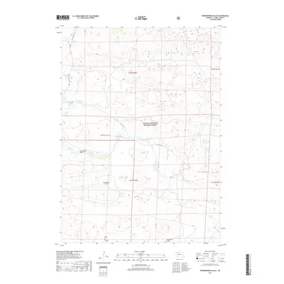
2017 Map of Powderhorn Valley
USGS Topo · Published 2017About this map
The Samuel R McKelvie National Forest dominates this section of the Nebraska Sandhills, a landscape defined by its distinctive dune formations and interdunal valleys. These low-lying areas, including Powderhorn Valley, Chamberlain Valley, and Tombstone Valley, served as the primary conduits for settlement and ranching activities. Water is a critical resource in this arid environment, evidenced by Steer Cr and the Lord Lakes, which provide vital hydration for the region's livestock. Human presence is sparsely marked but deeply rooted, with small local landmarks such as Lamson Cem and Larson Cem tucked into the southern reaches of the quadrangle. Access to these remote ranching lands is provided by State Hwy Spur 16F and maintained routes like Powder Horn Ranch Rd, illustrating the persistence of rural life in Cherry County.
Find a feature on this map
15 named features on this map. Tap any name to fly to it.
Don’t see what you’re looking for? This feature index may not catch every label — zoom into the map to look around manually.
Map Details
Editions of this 2017 Powderhorn Valley Map
This is the sole edition of this map. No revisions or reprints were ever made.
Other maps of this area

1950 · Powderhorn Valley
USGS Topo · 1:62,500

1950 · Kennedy
USGS Topo · 1:62,500

1950 · Kilgore
USGS Topo · 1:62,500

1950 · Cody
USGS Topo · 1:62,500

1957 · Valentine
USGS Topo · 1:250,000

1959 · Valentine
USGS Topo · 1:250,000

1985 · Powderhorn Valley SW
USGS Topo · 1:24,000

1985 · Cooper Canyon
USGS Topo · 1:24,000
1985 · Cody SE
USGS Topo · 1:24,000

1985 · Cody
USGS Topo · 1:100,000