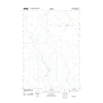
2012 Map of Powell NW
USGS Topo · Published 2012About this map
The high plains of Haakon County are defined here by a network of drainage systems and established family ranchlands. Settled sites like Heeb Ranch, Hickman Ranch, and Nelson Ranch are situated among the prairie landscape, often located near the vital water sources provided by Mitchell Cr and Witcher Holes Cr. The map illustrates the sparsely populated character of the West River region, where the primary land use remains large-scale ranching as evidenced by Buls Ranch to the south. Several seasonal waterways, including Sarah Laribee Cr, Nowlin Cr, and Buzzard Cr, create a distinct topography across the quadrangle, which is otherwise marked by an organized grid of section lines and gravel access roads.
Find a feature on this map
9 named features on this map. Tap any name to fly to it.
Don’t see what you’re looking for? This feature index may not catch every label — zoom into the map to look around manually.
Map Details
Editions of this 2012 Powell NW Map
This is the sole edition of this map. No revisions or reprints were ever made.
Other maps of this area

1953 · Philip SE
USGS Topo · 1:24,000

1954 · Powell
USGS Topo · 1:24,000

1954 · Nowlin
USGS Topo · 1:24,000

1954 · Pierre
USGS Topo · 1:250,000

1958 · Pierre
USGS Topo · 1:250,000

1983 · Mule Creek
USGS Topo · 1:24,000

1983 · Philip
USGS Topo · 1:100,000

1983 · Powell NW
USGS Topo · 1:24,000

1983 · Tornado Ranch
USGS Topo · 1:24,000
1983 · Ottumwa
USGS Topo · 1:24,000