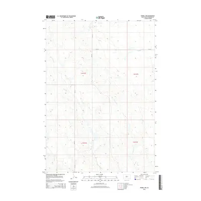
2015 Map of Powell NW
USGS Topo · Published 2015About this map
Mitchell Cr and Witcher Holes Cr carve through this section of the West River prairie in Haakon County, illustrating the drainage patterns that define the western South Dakota landscape. The map depicts a sparsely populated pastoral environment where land is divided into large sections within townships such as t3n r22e and t2n r23e. Transport in the mid-2010s relied on a geometric grid of rural routes, including the long-stretching 11 Mile Rd and Kronk Rd, which intersect to connect isolated ranch lands. Smaller waterways like Sarah Laribee Cr and Nowlin Cr wind across the terrain, highlighting the importance of seasonal water sources in this semi-arid region. This USGS survey provides a clear view of the modern land use and remote infrastructure in a traditional ranching territory.
Find a feature on this map
11 named features on this map. Tap any name to fly to it.
Don’t see what you’re looking for? This feature index may not catch every label — zoom into the map to look around manually.
Map Details
Editions of this 2015 Powell NW Map
This is the sole edition of this map. No revisions or reprints were ever made.
Other maps of this area

1953 · Philip SE
USGS Topo · 1:24,000

1954 · Powell
USGS Topo · 1:24,000

1954 · Nowlin
USGS Topo · 1:24,000

1954 · Pierre
USGS Topo · 1:250,000

1958 · Pierre
USGS Topo · 1:250,000

1983 · Mule Creek
USGS Topo · 1:24,000

1983 · Philip
USGS Topo · 1:100,000

1983 · Powell NW
USGS Topo · 1:24,000

1983 · Tornado Ranch
USGS Topo · 1:24,000
1983 · Ottumwa
USGS Topo · 1:24,000