
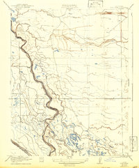
1922 Map of Pozo Farm
USGS Topo · Published 1922About this map
San Joaquin River meanders through the heart of this Central Valley landscape, defining the winding boundary between Madera Co and Fresno Co. The 1919 survey, published in 1922, reveals an intricate network of water management that supported early 20th-century agriculture and land use. Major waterways like the Fresno River and Berenda Slough feed into the lowlands, while the Pozo Canal and the San Joaquin and Kings River Canal illustrate the engineered redistribution of water for the eponymous Pozo Farm. Settlement patterns here are sparse, centered on large-scale ranching and land tracts. The presence of the Southern Pacific railroad line and the Rasin City Gun Club reflects the era's dual focus on industrial transport and regional recreation along the sloughs and riverbanks.
Find a feature on this map
11 named features on this map. Tap any name to fly to it.
Don’t see what you’re looking for? This feature index may not catch every label — zoom into the map to look around manually.
Map Details
Editions of this 1922 Pozo Farm Map
2 editions found
Other maps of this area

1913 · Panoche
USGS Topo · 1:125,000

1916 · Santa Rita Bridge
USGS Topo · 1:24,000

1918 · Bliss Ranch
USGS Topo · 1:31,680

1918 · Chowchilla
USGS Topo · 1:31,680

1920 · Santa Rita Bridge
USGS Topo · 1:31,680

1921 · Mendota
USGS Topo · 1:31,680

1922 · Oxalis
USGS Topo · 1:31,680

1922 · Santa Rita Bridge
USGS Topo · 1:31,680

1922 · Kentucky Well
USGS Topo · 1:31,680

1923 · Wisdom Well
USGS Topo · 1:31,680