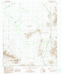
1990 Map of Pozo Nuevo Well
USGS Topo · Published 1990About this map
Organ Pipe Cactus National Monument dominates this desert landscape, where the convergence of several protected federal lands illustrates the complex land management of the Sonoran Desert in the late twentieth century. The map details a transition from the Cabeza Prieta National Wildlife Refuge and Wilderness in the west to the restricted zones of the Barry M Goldwater Air Force Range. Isolated water sources like Pozo Nuevo Well and the seasonal San Cristobal Wash define the survival patterns of this arid region. The presence of Jose Juan Tank and the defunct Cipriano Well (Dry) suggest the cattle ranching history that preceded the establishment of these wilderness preserves. Rising from the Growler Valley, the Bates Mountains and Agua Dulce Mountains create a topographical barrier between military training grounds and national monument lands.
Find a feature on this map
19 named features on this map. Tap any name to fly to it.
Don’t see what you’re looking for? This feature index may not catch every label — zoom into the map to look around manually.
Map Details
Editions of this 1990 Pozo Nuevo Well Map
This is the sole edition of this map. No revisions or reprints were ever made.
Other maps of this area

1953 · Ajo
USGS Topo · 1:250,000

1954 · Sonoyta
USGS Topo · 1:250,000

1957 · Ajo
USGS Topo · 1:250,000

1958 · Ajo
USGS Topo · 1:250,000

1962 · Ajo
USGS Topo · 1:250,000

1963 · Ajo
USGS Topo · 1:250,000

1963 · Lukeville
USGS Topo · 1:62,500

1963 · Quitobaquito Springs
USGS Topo · 1:62,500

1963 · Kino Peak
USGS Topo · 1:62,500

1963 · Lukeville
USGS Topo · 1:250,000