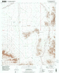
1996 Map of Pozo Nuevo Well
USGS Topo · Published 2000About this map
Growler Valley sits at the heart of a strictly managed desert landscape in the 1990s, defined by the convergence of major federal land holdings. The area serves as a critical buffer zone where the Barry M Goldwater Air Force Range meets the Organ Pipe Cactus National Monument and the Cabeza Prieta National Wildlife Refuge. While the terrain is dominated by the Agua Dulce Mountains and Bates Mountains, the presence of sparse water resources like Pozo Nuevo Well and the Cipriano Well (Dry) along the ephemeral San Cristobal Wash points to the historical importance of these isolated points for ranching or travel before the establishment of the surrounding wilderness areas. The network of unimproved tracks, such as the Pozo Nuevo Road, highlights the restricted accessibility of this protected Sonoran Desert environment.
Find a feature on this map
18 named features on this map. Tap any name to fly to it.
Don’t see what you’re looking for? This feature index may not catch every label — zoom into the map to look around manually.
Map Details
Editions of this 1996 Pozo Nuevo Well Map
This is the sole edition of this map. No revisions or reprints were ever made.
Other maps of this area

1953 · Ajo
USGS Topo · 1:250,000

1954 · Sonoyta
USGS Topo · 1:250,000

1957 · Ajo
USGS Topo · 1:250,000

1958 · Ajo
USGS Topo · 1:250,000

1962 · Ajo
USGS Topo · 1:250,000

1963 · Ajo
USGS Topo · 1:250,000

1963 · Lukeville
USGS Topo · 1:62,500

1963 · Quitobaquito Springs
USGS Topo · 1:62,500

1963 · Kino Peak
USGS Topo · 1:62,500

1963 · Lukeville
USGS Topo · 1:250,000