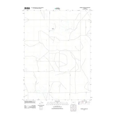
2012 Map of Prairie Center
USGS Topo · Published 2012About this map
Nichols Canyon defines the drainage patterns of this rural Goshen County landscape as it appeared in the early 21st century. This region of Wyoming is characterized by a sparse, grid-like network of county roads that facilitate access across the high plains. The map illustrates a primarily agricultural or ranching environment, where connectivity is maintained through thoroughfares such as McMaster Rd and Co Rd 19. The lack of dense township development highlights the open nature of this quadrangle, focusing instead on the subtle terrain of the canyon and the essential road infrastructure including Road 23 and Co Rd 18. These routes trace the path of local commerce and movement through a territory where natural landforms and surveying lines remain the primary landmarks.
Find a feature on this map
8 named features on this map. Tap any name to fly to it.
Don’t see what you’re looking for? This feature index may not catch every label — zoom into the map to look around manually.
Map Details
Editions of this 2012 Prairie Center Map
This is the sole edition of this map. No revisions or reprints were ever made.
Other maps of this area

1896 · Patrick
USGS Topo · 1:125,000

1954 · Torrington
USGS Topo · 1:250,000

1958 · Torrington
USGS Topo · 1:250,000

1974 · Mc Master Reservoir
USGS Topo · 1:24,000

1974 · Jay Em
USGS Topo · 1:24,000

1977 · Hileman Draw
USGS Topo · 1:24,000

1977 · Van Tassell
USGS Topo · 1:24,000

1977 · Van Tassell SE
USGS Topo · 1:24,000

1977 · Prairie Center
USGS Topo · 1:24,000
1977 · Spoon Butte NW
USGS Topo · 1:24,000