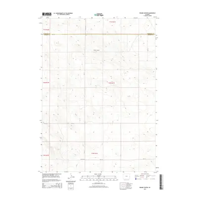
2015 Map of Prairie Center
USGS Topo · Published 2015About this map
Prairie Center sits at the southern edge of this high plains landscape, situated at the junction of Road 47 and Road 132. The map illustrates a vast, open cattle-country environment where the terrain is subtly defined by features like Nichols Canyon, which cuts through the central sections. The primary organizational structure of the land follows the Public Land Survey System, with township and range lines like t30n r61w and t29n r61w providing the grid for homesteading and ranching operations.
Find a feature on this map
16 named features on this map. Tap any name to fly to it.
Don’t see what you’re looking for? This feature index may not catch every label — zoom into the map to look around manually.
Map Details
Editions of this 2015 Prairie Center Map
This is the sole edition of this map. No revisions or reprints were ever made.
Other maps of this area

1896 · Patrick
USGS Topo · 1:125,000

1954 · Torrington
USGS Topo · 1:250,000

1958 · Torrington
USGS Topo · 1:250,000

1974 · Mc Master Reservoir
USGS Topo · 1:24,000

1974 · Jay Em
USGS Topo · 1:24,000

1977 · Hileman Draw
USGS Topo · 1:24,000

1977 · Van Tassell
USGS Topo · 1:24,000

1977 · Van Tassell SE
USGS Topo · 1:24,000

1977 · Prairie Center
USGS Topo · 1:24,000
1977 · Spoon Butte NW
USGS Topo · 1:24,000