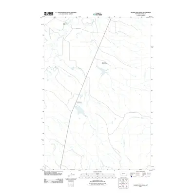
2011 Map of Prairie Dog Creek
USGS Topo · Published 2011About this map
Prairie Dog Creek meanders through this remote portion of Carter County, Montana, carving a drainage pattern through a landscape defined by intermittent waterways and specialized water management. The infrastructure here is notably tied to ranching or local land use, as evidenced by the Earl Krietel Number 3 Dam and Earl Krietel Number 4 Dam. These features illustrate how early 21st-century inhabitants adapted to the semi-arid environment of the Great Plains by creating reliable reservoirs along drainage routes like Ewalt Draw and the various tributaries of Boxelder Creek. Transportation is sparse, anchored by rural thoroughfares such as Hammond Rd and Cottonwood Creek Rd, which provide the primary access to the isolated drainages of Hawksnest Creek and Cottonwood Creek.
Find a feature on this map
9 named features on this map. Tap any name to fly to it.
Don’t see what you’re looking for? This feature index may not catch every label — zoom into the map to look around manually.
Map Details
Editions of this 2011 Prairie Dog Creek Map
This is the sole edition of this map. No revisions or reprints were ever made.
Other maps of this area

1954 · Ekalaka
USGS Topo · 1:250,000

1956 · Ekalaka
USGS Topo · 1:250,000

1958 · Ekalaka
USGS Topo · 1:250,000

1965 · Ekalaka
USGS Topo · 1:250,000

1979 · Ikey Creek
USGS Topo · 1:24,000

1980 · Prairie Dog Creek
USGS Topo · 1:24,000

1980 · Finger Buttes East
USGS Topo · 1:24,000

1980 · Belltower Butte
USGS Topo · 1:24,000
1980 · School Section Creek
USGS Topo · 1:24,000
1980 · Lone Tree Creek
USGS Topo · 1:24,000