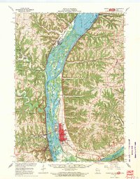
1967 Map of Prairie Du Chien
USGS Topo · Published 1969About this map
The confluence of the Mississippi River and the Wisconsin River dominates this mid-century survey, anchoring the strategic location of Prairie Du Chien. The landscape is a complex network of backwaters and islands, including Ryan Island and Hunter Island, which shaped the early development of riverfront towns like McGregor and Marquette. On the western bluffs, the Effigy Mounds National Monument preserves ancient earthworks, while the surrounding ridges are dotted with local landmarks like Du Charme Ridge and Famechon Ridge.
Find a feature on this map
76 named features on this map. Tap any name to fly to it.
Don’t see what you’re looking for? This feature index may not catch every label — zoom into the map to look around manually.
Map Details
Editions of this 1967 Prairie Du Chien Map
This is the sole edition of this map. No revisions or reprints were ever made.
Other maps of this area

1900 · Lancaster
USGS Topo · 1:125,000

1902 · Elkader
USGS Topo · 1:125,000

1903 · Waukon
USGS Topo · 1:125,000

1904 · Lancaster
USGS Topo · 1:125,000

1908 · Lancaster
USGS Topo · 1:125,000

1924 · Gays Mills
USGS Topo · 1:62,500

1926 · Gays Mills
USGS Topo · 1:62,500

1926 · Wauzeka
USGS Topo · 1:62,500

1929 · Ferryville
USGS Topo · 1:62,500

1929 · Prairie Du Chien
USGS Topo · 1:62,500