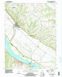
1993 Map of Prairie Du Rocher
USGS Topo · Published 1996About this map
The Mississippi River creates a dynamic border between Illinois and Missouri here, carving through a landscape defined by expansive bottomlands and dramatic bluffs. The village of Prairie du Rocher sits at the foot of these heights, near the Prairie du Rocher Creek, while the Modoc Rock Shelter National Historic Site signifies the deep human history of the region. The map captures a complex system of river management, featuring extensive levee systems and drainage features like The Discharge that protect the agricultural flats and settlements like Kellogg and Modoc. Along the riverbanks, old ferry and steamboat points such as Little Rock Landing and Mudds Landing point to the area's long-standing reliance on the river for transport. Inland, the terrain rises into wooded ridges and hollows like Barbeau Hollow, where numerous Mines and Quarries indicate the local extraction industries of the late 20th century.
Find a feature on this map
31 named features on this map. Tap any name to fly to it.
Don’t see what you’re looking for? This feature index may not catch every label — zoom into the map to look around manually.
Map Details
Editions of this 1993 Prairie Du Rocher Map
This is the sole edition of this map. No revisions or reprints were ever made.
Other maps of this area

1907 · Weingarten
USGS Topo · 1:62,500

1909 · Weingarten
USGS Topo · 1:62,500

1912 · Baldwin
USGS Topo · 1:62,500

1914 · Baldwin
USGS Topo · 1:62,500

1915 · Renault
USGS Topo · 1:62,500

1915 · Chester
USGS Topo · 1:62,500

1940 · Renault
USGS Topo · 1:62,500

1942 · Baldwin
USGS Topo · 1:62,500

1947 · Chester
USGS Topo · 1:62,500

1949 · Saint Louis
USGS Topo · 1:250,000