1942 Map of Baldwin
USGS Topo · Published 1960About this map
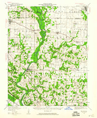
The Kaskaskia River winds prominently through this southwestern Illinois landscape, defining the character of several surrounding townships including Baldwin and Evansville. This survey, revised in the early 1940s, shows a highly developed rural infrastructure marked by a dense network of country schools, such as Charter Oak School and Jordan Grove School, which served the farming communities before the era of district consolidation. Transportation is anchored by the Mobile and Ohio and Illinois Southern railroads, which facilitated the movement of goods and people through settlements like Red Bud and Marissa. The presence of many family-named schools and small hamlets like Ruma and Schuline provides a detailed look at the social geography of Randolph, Monroe, and St. Clair counties at mid-century.
Find a feature on this map
66 named features on this map. Tap any name to fly to it.
Don’t see what you’re looking for? This feature index may not catch every label — zoom into the map to look around manually.
Map Details
Editions of this 1942 Baldwin Map
This is the sole edition of this map. No revisions or reprints were ever made.
Other maps of this area

1907 · Weingarten
USGS Topo · 1:62,500

1909 · Weingarten
USGS Topo · 1:62,500

1910 · Okawville
USGS Topo · 1:62,500

1910 · Waterloo
USGS Topo · 1:62,500

1912 · New Athens
USGS Topo · 1:62,500

1912 · Baldwin
USGS Topo · 1:62,500

1913 · Waterloo
USGS Topo · 1:62,500

1914 · Baldwin
USGS Topo · 1:62,500

1914 · Coulterville
USGS Topo · 1:62,500

1915 · Renault
USGS Topo · 1:62,500