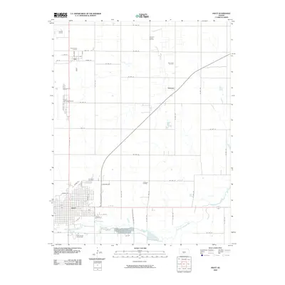
2009 Map of Pratt
USGS Topo · Published 2009About this map
The Pratt county seat and its surrounding agricultural plains are defined by the convergence of regional transport and energy extraction in the early 21st century. The South Fork Ninnescah River meanders across the southern portion of the quadrangle, feeding into Pratt County Lake near the Pratt County Fairgrounds. North of the city, the landscape is partitioned by a rigid grid of section roads like NE 70th St, interspersed with active energy sites such as the Iuka-Carmi Oil and Gas Field and the Chance Oil Field.
Find a feature on this map
35 named features on this map. Tap any name to fly to it.
Don’t see what you’re looking for? This feature index may not catch every label — zoom into the map to look around manually.
Map Details
Editions of this 2009 Pratt Map
This is the sole edition of this map. No revisions or reprints were ever made.
Other maps of this area

1892 · Pratt
USGS Topo · 1:125,000

1894 · Pratt
USGS Topo · 1:125,000

1955 · Pratt
USGS Topo · 1:250,000

1959 · Pratt
USGS Topo · 1:250,000

1967 · Cairo
USGS Topo · 1:24,000

1968 · Pratt SW
USGS Topo · 1:24,000

1968 · Pratt
USGS Topo · 1:24,000

1968 · Coats
USGS Topo · 1:24,000

1968 · Coats NE
USGS Topo · 1:24,000
1968 · Pratt SE
USGS Topo · 1:24,000