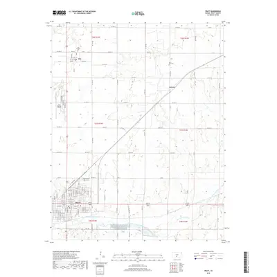
2018 Map of Pratt
USGS Topo · Published 2018About this map
Pratt serves as the central hub of this Kansas landscape, where the urban grid meets the agricultural reaches of the High Plains. The South Fork Ninnescah River meanders across the southern portion of the sheet, providing a natural contrast to the rigid section lines that define the surrounding territory. To the north, the small settlements of Iuka and Natrona are situated along the rail and road corridors that facilitate the region's grain-based economy. For those tracing local heritage, the map identifies several significant locations including Iuka Township Cem, Saint Pauls Cem, and Greenlawn Cem. The presence of the Pratt Regional Airport northwest of the city center marks a significant modern infrastructure point amidst the traditional township and range survey lines of t27s r13w and t28s r12w.
Find a feature on this map
65 named features on this map. Tap any name to fly to it.
Don’t see what you’re looking for? This feature index may not catch every label — zoom into the map to look around manually.
Map Details
Editions of this 2018 Pratt Map
This is the sole edition of this map. No revisions or reprints were ever made.
Other maps of this area

1892 · Pratt
USGS Topo · 1:125,000

1894 · Pratt
USGS Topo · 1:125,000

1955 · Pratt
USGS Topo · 1:250,000

1959 · Pratt
USGS Topo · 1:250,000

1967 · Cairo
USGS Topo · 1:24,000

1968 · Pratt SW
USGS Topo · 1:24,000

1968 · Pratt
USGS Topo · 1:24,000

1968 · Coats
USGS Topo · 1:24,000

1968 · Coats NE
USGS Topo · 1:24,000
1968 · Pratt SE
USGS Topo · 1:24,000