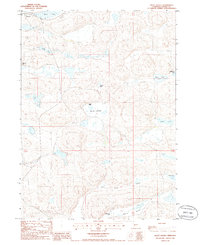
1985 Map of Pratt Valley
USGS Topo · Published 1986About this map
Hyannis anchors the northwest corner of this mid-1980s Nebraska landscape, where the Sandhills terrain is defined by a dense cluster of lakes and ranching operations. The area is marked by numerous water bodies including Beem Lake, Long Lake, and Negro Lake, while the expansive Moran Lakebed suggests the shifting hydrology of this prairie environment. Remote cattle ranching is the primary footprint of human activity, illustrated by dispersed sites such as Wheelock Ranch, Sheperd Ranch, and Lynch Circle Ranch. The map also captures local topographical depressions like Pratt Valley and Winnie Valley. For researchers, the presence of the Sewage Disposal Pond near the town center and several unnamed 4WD trails provides insight into the infrastructure and accessibility of this rural region during the late twentieth century.
Find a feature on this map
18 named features on this map. Tap any name to fly to it.
Don’t see what you’re looking for? This feature index may not catch every label — zoom into the map to look around manually.
Map Details
Editions of this 1985 Pratt Valley Map
This is the sole edition of this map. No revisions or reprints were ever made.
Other maps of this area

1948 · Ashby
USGS Topo · 1:62,500

1948 · George Lake
USGS Topo · 1:62,500

1948 · Whitman
USGS Topo · 1:62,500

1948 · Spring Valley
USGS Topo · 1:62,500

1949 · Ashby
USGS Topo · 1:62,500

1950 · Spring Valley
USGS Topo · 1:62,500

1950 · Whitman
USGS Topo · 1:62,500

1950 · George Lake
USGS Topo · 1:62,500

1954 · North Platte
USGS Topo · 1:250,000

1956 · North Platte
USGS Topo · 1:250,000