
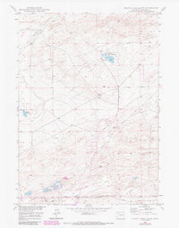
1949 Map of Pratts Soda Lakes
USGS Topo · Published 1975About this map
Pratts Soda Lakes and the isolated Suicide Soda Lake define the arid alkali-rich landscape of this Natrona County region during the late 1940s. The terrain is marked by a transition from traditional routes to industrial development, featuring the historic path of the Emigrant Trail cutting across the southern portion of the quadrangle. This path runs nearly parallel to the more modern Geary Dome Road, illustrating the evolution of transport in the Wyoming interior. Resource extraction is evident through the presence of the Blue Rock Coal Mine and Swigart Coal Mine, along with a burgeoning network of energy infrastructure represented by an Oil Pipe Line and Telephone Line that crisscross the sagebrush flats and high ridges near Campbell Hill.
Find a feature on this map
12 named features on this map. Tap any name to fly to it.
Don’t see what you’re looking for? This feature index may not catch every label — zoom into the map to look around manually.
Map Details
Editions of this 1949 Pratts Soda Lakes Map
2 editions found
Other maps of this area

1949 · Brookhurst
USGS Topo · 1:24,000

1949 · Campbell Hill
USGS Topo · 1:24,000

1950 · Campbell Hill
USGS Topo · 1:24,000

1950 · Lockett
USGS Topo · 1:24,000

1950 · Brookhurst
USGS Topo · 1:24,000

1950 · Pratts Soda Lakes
USGS Topo · 1:24,000

1951 · The Reefs
USGS Topo · 1:24,000

1951 · Casper
USGS Topo · 1:24,000

1955 · Arminto
USGS Topo · 1:250,000

1955 · Casper
USGS Topo · 1:250,000