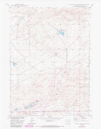
1949 Map of Pratts Soda Lakes
USGS Topo · Published 1985About this map
The Emigrant Trail cuts across this high plains landscape of Natrona County, marking a historic corridor of western movement through a region defined by its industrial resources. At the mid-century, energy extraction and mining activity are central to the area's development, evidenced by the Swigart Coal Mine and Blue Rock Coal Mine located south of the distinctive water features. A network of infrastructure supports these operations, including several Windmills scattered across the terrain and the Geary Dome Road to the south. The hydrology is unique, characterized by the namesake Pratts Soda Lakes and the ominously named Suicide Soda Lake. These alkaline water bodies, along with the drainage of Sand Creek, shape the settlement pattern and land use in this part of the Missouri River Basin development program.
Find a feature on this map
15 named features on this map. Tap any name to fly to it.
Don’t see what you’re looking for? This feature index may not catch every label — zoom into the map to look around manually.
Map Details
Editions of this 1949 Pratts Soda Lakes Map
2 editions found
Other maps of this area

1949 · Brookhurst
USGS Topo · 1:24,000

1949 · Campbell Hill
USGS Topo · 1:24,000

1949 · Pratts Soda Lakes
USGS Topo · 1:24,000

1950 · Campbell Hill
USGS Topo · 1:24,000

1950 · Lockett
USGS Topo · 1:24,000

1950 · Brookhurst
USGS Topo · 1:24,000

1950 · Pratts Soda Lakes
USGS Topo · 1:24,000

1951 · The Reefs
USGS Topo · 1:24,000

1951 · Casper
USGS Topo · 1:24,000

1955 · Arminto
USGS Topo · 1:250,000