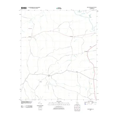
2011 Map of Prattsburg
USGS Topo · Published 2011About this map
Prattsburg and Carsonville sit along a network of county roads in this portion of Taylor County, defined by the winding course of the Flint River and its numerous tributaries. The landscape is marked by small settlements and rural crossroads like Five Points, Jarrell, and Wesley, which serve as focal points for the surrounding agricultural and timber lands. Water features heavily in the geography of the area, from the sprawling Three Fingered Lake and Green Lake in the northeast to the various creeks like Little Patsiliga Creek, Barfield Creek, and Richland Creek that drain the terrain.
Find a feature on this map
45 named features on this map. Tap any name to fly to it.
Don’t see what you’re looking for? This feature index may not catch every label — zoom into the map to look around manually.
Map Details
Editions of this 2011 Prattsburg Map
This is the sole edition of this map. No revisions or reprints were ever made.
Other maps of this area

1935 · Thomaston
USGS Topo · 1:48,000

1939 · Thomaston
USGS Topo · 1:62,500

1951 · Yatesville
USGS Topo · 1:62,500

1955 · Phenix City
USGS Topo · 1:250,000

1957 · Phenix City
USGS Topo · 1:250,000

1958 · Phenix City
USGS Topo · 1:250,000
1971 · Roland
USGS Topo · 1:24,000

1971 · Prattsburg
USGS Topo · 1:24,000
1971 · Baldwinville
USGS Topo · 1:24,000
1971 · Lincoln Park
USGS Topo · 1:24,000