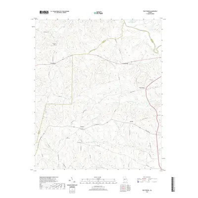
2020 Map of Prattsburg
USGS Topo · Published 2020About this map
Prattsburg and the surrounding rural communities of Taylor County are defined by a network of local roads and creek drainages in this modern survey. The terrain is deeply carved by the Little Patsiliga Creek and the Flint River at the northeastern corner, where Three Fingered Lake and Green Lake sit just south of the Upson Co line. Smaller settlements like Wesley, Jarrell, and Five Points are connected by historical routes including W Old Wire Rd and Wesley Church Rd. Genealogists will find several significant burial sites, including Wesley Church Cem, Scott-Bussy Cem, and Antioch Cem. The presence of the Prattsburg Airport northwest of the main settlement indicates the area's continued role as a local transit and agricultural hub within the Georgia Piedmont.
Find a feature on this map
50 named features on this map. Tap any name to fly to it.
Don’t see what you’re looking for? This feature index may not catch every label — zoom into the map to look around manually.
Map Details
Editions of this 2020 Prattsburg Map
This is the sole edition of this map. No revisions or reprints were ever made.
Other maps of this area

1935 · Thomaston
USGS Topo · 1:48,000

1939 · Thomaston
USGS Topo · 1:62,500

1951 · Yatesville
USGS Topo · 1:62,500

1955 · Phenix City
USGS Topo · 1:250,000

1957 · Phenix City
USGS Topo · 1:250,000

1958 · Phenix City
USGS Topo · 1:250,000
1971 · Roland
USGS Topo · 1:24,000

1971 · Prattsburg
USGS Topo · 1:24,000
1971 · Baldwinville
USGS Topo · 1:24,000
1971 · Lincoln Park
USGS Topo · 1:24,000