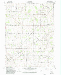
1962 Map of Preble
USGS Topo · Published 1994About this map
The boundary between Wells and Adams Counties serves as the central axis for this rural Indiana landscape, which was meticulously documented in the early 1960s. The region is defined by a dense network of agricultural drainage channels, including the Eightmile No 2 Ditch and the Holthouse Ditch, which underscore the intensive land management required for local farming. Small unincorporated hamlets such as Tocsin, Magley, and Preble are linked by straight section-line roads, many of which are punctuated by community-focused sites like Bethlehem School and St Pauls Church.
Find a feature on this map
52 named features on this map. Tap any name to fly to it.
Don’t see what you’re looking for? This feature index may not catch every label — zoom into the map to look around manually.
Map Details
Editions of this 1962 Preble Map
2 editions found
Other maps of this area

1911 · Berne
USGS Topo · 1:48,000

1953 · Muncie
USGS Topo · 1:250,000

1956 · Muncie
USGS Topo · 1:250,000

1961 · Hoagland
USGS Topo · 1:24,000

1962 · Poe
USGS Topo · 1:24,000

1962 · Uniondale
USGS Topo · 1:24,000

1962 · Ossian
USGS Topo · 1:24,000

1962 · Preble
USGS Topo · 1:24,000

1962 · Berne
USGS Topo · 1:24,000
1962 · Decatur
USGS Topo · 1:24,000