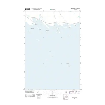
2011 Map of Prentiss Bay
USGS Topo · Published 2011About this map
Prentiss Bay and the jagged shoreline of Mackinac County characterize this coastal study of the Lake Huron waterfront. The area is defined by a series of deep-water indentations including Scotty Bay, Beaver Tail Bay, and Dudley Bay, separated by distinctive landforms such as Whitefish Point and Beaver Tail Point. Inland, the landscape is dotted with smaller bodies of water like Loon Lake and Little Trout Lake, while the Cedar Campus Camp sits near the head of the primary bay. Submerged hazards are a prominent feature of these waters, with several named shallows like Surveyors Reef, Tobin Reef, and Pomeroy Reef extending well out from the coast. This map illustrates the transition from the wooded shores of the Upper Peninsula to the complex maritime environment of the northern Great Lakes, where isolated points like Cadogan Point and Stevenson Point reach into the open water.
Find a feature on this map
32 named features on this map. Tap any name to fly to it.
Don’t see what you’re looking for? This feature index may not catch every label — zoom into the map to look around manually.
Map Details
Editions of this 2011 Prentiss Bay Map
This is the sole edition of this map. No revisions or reprints were ever made.
Other maps of this area

1931 · Pickford SE
USGS Topo · 1:31,680

1954 · Sault Sainte Marie
USGS Topo · 1:250,000

1955 · Cheboygan
USGS Topo · 1:250,000

1956 · Sault Sainte Marie
USGS Topo · 1:250,000

1957 · Sault Sainte Marie
USGS Topo · 1:250,000

1958 · Cheboygan
USGS Topo · 1:250,000

1958 · Sault Sainte Marie
USGS Topo · 1:250,000
1964 · Albany Island
USGS Topo · 1:24,000
1964 · Stalwart
USGS Topo · 1:24,000
1964 · Prentiss Bay
USGS Topo · 1:24,000