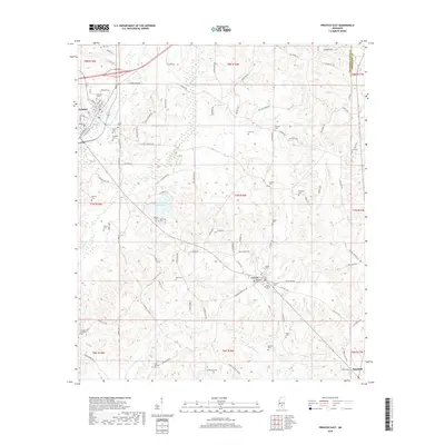
2018 Map of Prentiss East
USGS Topo · Published 2018About this map
Prentiss serves as a primary hub in this central Mississippi landscape, where a dense network of local roads such as Columbia Ave and St Stephens Rd connects long-standing family settlements and rural burial grounds. The survey reveals a high concentration of genealogical sites, from the Magee Cem and Tyrone Cem near the town center to the remote Clear Springs Cem in the south. The terrain is defined by the winding paths of White Sand Cr and Jaybird Creek, which feed into Jefferson Davis Lake. This late 2010s data shows the community of Carson anchored by Saint Elizabeth Cem and Carson Cem, reflecting a settlement pattern that remains tied to traditional crossroads and small-scale agriculture even as modern infrastructure like Dewey-Polk Rd spans the northern reaches of the county.
Find a feature on this map
117 named features on this map. Tap any name to fly to it.
Don’t see what you’re looking for? This feature index may not catch every label — zoom into the map to look around manually.
Map Details
Editions of this 2018 Prentiss East Map
This is the sole edition of this map. No revisions or reprints were ever made.
Other maps of this area

1953 · Hattiesburg
USGS Topo · 1:250,000

1958 · Hattiesburg
USGS Topo · 1:250,000

1970 · Prentiss West
USGS Topo · 1:24,000

1970 · Bunker Hill
USGS Topo · 1:24,000

1970 · Oak Vale
USGS Topo · 1:24,000

1970 · New Hebron
USGS Topo · 1:24,000

1970 · Prentiss East
USGS Topo · 1:24,000

1970 · Mount Carmel
USGS Topo · 1:24,000

1974 · Lone Star
USGS Topo · 1:24,000

1974 · Bassfield
USGS Topo · 1:24,000