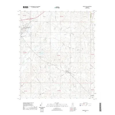
2020 Map of Prentiss East
USGS Topo · Published 2020About this map
The town of Prentiss serves as the seat of Jefferson Davis County, anchored by the Jefferson Davis County Building Circuit Court and the Chancery Court. The surrounding countryside is defined by an exceptionally high density of small family and community burial grounds, illustrating a deeply rooted rural settlement pattern. From the Saint Elizabeth Cem near Carson to the Clear Springs Cem in the south, these sites provide a granular record of local genealogy. The landscape is carved by numerous watercourses, including White Sand Creek, Jaybird Creek, and Holliday Cr, which feed into the broader regional drainage system. Jefferson Davis Lake provides a central water feature amidst the complex network of local roads like Bass Hathorn Rd and Fate Ward Rd that connect the scattered homesites and agricultural lands.
Find a feature on this map
102 named features on this map. Tap any name to fly to it.
Don’t see what you’re looking for? This feature index may not catch every label — zoom into the map to look around manually.
Map Details
Editions of this 2020 Prentiss East Map
This is the sole edition of this map. No revisions or reprints were ever made.
Other maps of this area

1953 · Hattiesburg
USGS Topo · 1:250,000

1958 · Hattiesburg
USGS Topo · 1:250,000

1970 · Prentiss West
USGS Topo · 1:24,000

1970 · Bunker Hill
USGS Topo · 1:24,000

1970 · Oak Vale
USGS Topo · 1:24,000

1970 · New Hebron
USGS Topo · 1:24,000

1970 · Prentiss East
USGS Topo · 1:24,000

1970 · Mount Carmel
USGS Topo · 1:24,000

1974 · Lone Star
USGS Topo · 1:24,000

1974 · Bassfield
USGS Topo · 1:24,000