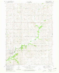
1980 Map of Prescott
USGS Topo · Published 1981About this map
The Nodaway River and the East Nodaway River converge just west of Prescott, anchoring a landscape defined by the intersection of rail transport and rural community centers in Adams County. This 1980s-era survey documents the Burlington Northern railroad as it cuts through the township, supporting the local agricultural economy and the town's central Townhall. For genealogists, the map provides precise locations for several distinct burial grounds, including the Bohemian National Cem in the north and the Old Evergreen Cem near the riverbanks. Beyond the primary settlement, the map identifies small locales like Dougherty and Graves, which along with Mt Zion Branch and Shanghai Creek, illustrate the historical drainage patterns and naming conventions of the Iowa countryside during the late twentieth century.
Find a feature on this map
25 named features on this map. Tap any name to fly to it.
Don’t see what you’re looking for? This feature index may not catch every label — zoom into the map to look around manually.
Map Details
Editions of this 1980 Prescott Map
This is the sole edition of this map. No revisions or reprints were ever made.
Other maps of this area

1954 · Omaha
USGS Topo · 1:250,000

1955 · Nebraska City
USGS Topo · 1:250,000

1957 · Nebraska City
USGS Topo · 1:250,000

1957 · Omaha
USGS Topo · 1:250,000

1958 · Omaha
USGS Topo · 1:250,000

1958 · Nebraska City
USGS Topo · 1:250,000

1980 · Corning South
USGS Topo · 1:24,000

1980 · Lenox
USGS Topo · 1:24,000

1980 · Nevinville
USGS Topo · 1:24,000

1980 · Corning North
USGS Topo · 1:24,000