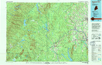
1994 Map of Presque Isle
USGS Topo · Published 1994About this map
Presque Isle serves as the focal point of this Northern Maine landscape, situated where the Aroostook River meets a network of local streams and agricultural lands. In the mid-1990s, the region's economy is clearly defined by its transportation corridors, with the Bangor & Aroostook RR winding through riverside settlements like Ashland, Masardis, and Washburn. The map illustrates a transition from the structured township grids of Mapleton and Castle Hill to the denser woodlands and water bodies of the west, including Portage Lake and St Froid Lake.
Find a feature on this map
114 named features on this map. Tap any name to fly to it.
Don’t see what you’re looking for? This feature index may not catch every label — zoom into the map to look around manually.
Map Details
Editions of this 1994 Presque Isle Map
This is the sole edition of this map. No revisions or reprints were ever made.
Other maps of this area

1921 · Van Buren
USGS Topo · 1:250,000

1927 · Stockholm
USGS Topo · 1:48,000

1927 · Square Lake
USGS Topo · 1:48,000

1928 · Eagle Lake
USGS Topo · 1:48,000

1928 · Winterville
USGS Topo · 1:48,000

1929 · Portage
USGS Topo · 1:62,500

1929 · Caribou
USGS Topo · 1:48,000

1930 · Greenlaw
USGS Topo · 1:48,000

1930 · Allagash
USGS Topo · 1:48,000

1930 · Fort Fairfield
USGS Topo · 1:48,000