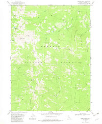
1982 Map of Preston Peak
USGS Topo · Published 1982About this map
Preston Peak dominates the center of this high-elevation landscape within the Klamath National Forest, where the complex drainage systems of the Siskiyou mountains are clearly defined. The terrain is characterized by prominent ridges such as Cedar Crest and the Elk Lick Ridge, which separate deep canyons carved by Indian Creek and Preston Creek. A single unnamed Mine near Cyclone Gap in the northwest corner suggests the prospecting history of the area, while names like Rattlesnake Meadow and Elk Lick point to the early identification of specific habitats and natural features by surveyors and hunters. The map illustrates a high-country wilderness largely accessible by 4WD tracks and trails, centering on the granite spires of El Capitan and the alpine waters of Raspberry Lake. To the south, the Five and Ten Divide creates a notable watershed boundary between Tenmile Creek and Fivemile Creek.
Find a feature on this map
29 named features on this map. Tap any name to fly to it.
Don’t see what you’re looking for? This feature index may not catch every label — zoom into the map to look around manually.
Map Details
Editions of this 1982 Preston Peak Map
This is the sole edition of this map. No revisions or reprints were ever made.
Other maps of this area

1914 · Seiad
USGS Topo · 1:125,000

1922 · Preston Peak
USGS Topo · 1:125,000

1922 · Seiad
USGS Topo · 1:125,000

1948 · Weed
USGS Topo · 1:250,000

1950 · Weed
USGS Topo · 1:250,000

1955 · Dillon Mtn
USGS Topo · 1:62,500

1955 · Ukonom Lake
USGS Topo · 1:62,500

1956 · Happy Camp
USGS Topo · 1:62,500

1956 · Preston Peak
USGS Topo · 1:62,500

1958 · Weed
USGS Topo · 1:250,000