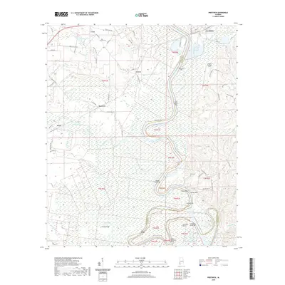
2020 Map of Prestwick
USGS Topo · Published 2020About this map
The Tombigbee River snakes through the heart of this landscape along the border of Washington and Clarke Counties, defining a terrain of river bars and intricate wetlands. The geography is marked by the shifting path of the water, featuring named landforms such as Blackwells Bar, East Bassetts Bar, and the sharp bend at Sunflower Bend. To the east, the city of Jackson establishes an urban edge with its Jackson Municipal Airport and City of Jackson Sewage Lagoon. Historically significant rural roads like Lower Ferry Rd and Powell Cut-Off Rd connect smaller communities like Leroy, Carson, and Wagar. The western half of the map is dominated by the vast Big Swamp and elevation features like Hickory Ridge, providing a detailed view of the bottomlands before the river meets the Upper Cutoff.
Find a feature on this map
78 named features on this map. Tap any name to fly to it.
Don’t see what you’re looking for? This feature index may not catch every label — zoom into the map to look around manually.
Map Details
Editions of this 2020 Prestwick Map
This is the sole edition of this map. No revisions or reprints were ever made.
Other maps of this area

1943 · Choctaw Bluff
USGS Topo · 1:62,500

1943 · McIntosh
USGS Topo · 1:62,500

1944 · McIntosh
USGS Topo · 1:62,500

1946 · Choctaw Bluff
USGS Topo · 1:62,500

1953 · Andalusia
USGS Topo · 1:250,000

1953 · Hattiesburg
USGS Topo · 1:250,000

1957 · Andalusia
USGS Topo · 1:250,000

1958 · Hattiesburg
USGS Topo · 1:250,000

1972 · St. Stephens
USGS Topo · 1:24,000

1978 · Jackson
USGS Topo · 1:24,000