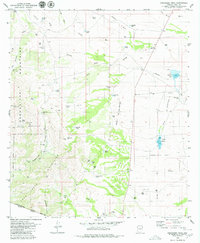
1979 Map of Presumido Peak
USGS Topo · Published 1980About this map
The Baboquivari Mountains and Pozo Verde Mountains define this high-desert landscape along the international border in southern Arizona. At the edge of the Papago Indian Reservation, the map captures a network of working ranches and seasonal water management features essential for cattle operations in a dry climate. Notable cattle-era landmarks include Buenos Aires Ranch and Sierra Vista Ranch, alongside smaller outposts like Los Encinos Ranch. The importance of water security is visible in the numerous earthen works and natural catchments such as Osa Dam, Mormon Lake, and Aguirre Lake. These features, along with names like Presumido Pass and Compartidero Flats, reflect a long history of transborder movement and land use near the small settlement of Sasabe.
Find a feature on this map
50 named features on this map. Tap any name to fly to it.
Don’t see what you’re looking for? This feature index may not catch every label — zoom into the map to look around manually.
Map Details
Editions of this 1979 Presumido Peak Map
2 editions found
Other maps of this area

1920 · Arivaca
USGS Topo · 1:125,000

1921 · Old Glory
USGS Topo · 1:125,000

1941 · Presumido Peak
USGS Topo · 1:62,500

1941 · Arivaca
USGS Topo · 1:62,500

1942 · Oro Blanco
USGS Topo · 1:62,500

1943 · Fresnal
USGS Topo · 1:125,000

1943 · Arivaca
USGS Topo · 1:62,500

1943 · Old Glory
USGS Topo · 1:125,000

1943 · Presumido Peak
USGS Topo · 1:62,500

1944 · Oro Blanco
USGS Topo · 1:62,500