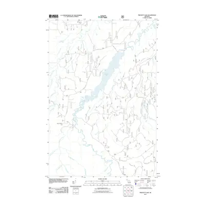
2011 Map of Prickett Lake
USGS Topo · Published 2011About this map
Prickett Lake dominates the central landscape of this Upper Peninsula survey, where the Sturgeon River is harnessed by the Prickett Dam. The surrounding terrain in Baraga County is defined by a dense network of watercourses and forestry access routes, including Fire Line Rd and Forest Rd 193. To the southwest, the topography rises toward Silver Mount, overlooking the drainage basins of the Little Silver River and Mountain Creek. A notable hydrological feature is Sturgeon Falls, located south of the main reservoir where the river cuts through the northern woodlands. The map documents a rugged interior focused on water management and timber access, with numerous named seasonal and perennial streams like Farce Creek and Dry Wash Creek carving through the glaciated Michigan landscape.
Find a feature on this map
39 named features on this map. Tap any name to fly to it.
Don’t see what you’re looking for? This feature index may not catch every label — zoom into the map to look around manually.
Map Details
Editions of this 2011 Prickett Lake Map
This is the sole edition of this map. No revisions or reprints were ever made.
Other maps of this area

1954 · Rousseau
USGS Topo · 1:62,500

1954 · Pelkie
USGS Topo · 1:62,500

1954 · Winona
USGS Topo · 1:62,500

1954 · Sidnaw
USGS Topo · 1:62,500

1958 · Iron River
USGS Topo · 1:250,000

1960 · Iron River
USGS Topo · 1:250,000

1961 · Iron River
USGS Topo · 1:250,000

1967 · Iron River
USGS Topo · 1:250,000
1982 · Nisula
USGS Topo · 1:25,000
1982 · Echo Lake
USGS Topo · 1:25,000