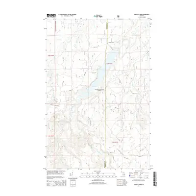
2014 Map of Prickett Lake
USGS Topo · Published 2014About this map
Prickett Lake sits at the center of this Upper Peninsula landscape, formed by the impoundment of the Sturgeon River near the border of Houghton and Baraga Counties. The area is characterized by a dense network of forest service roads and watercourses within the Ottawa National Forest, indicating a territory managed for timber and recreation. To the west, the prominent Silver Mt rises above the drainage of the Silver River and Little Silver River. The presence of the Prickett Dam and the Fishing Site Rd suggests the reservoir's role as a local focal point for utility and sport. Hikers can trace the winding path of the N Country National Scenic Trail as it traverses the western hills and crosses several creeks, including Couch Cr, before continuing toward the eastern ridges.
Find a feature on this map
43 named features on this map. Tap any name to fly to it.
Don’t see what you’re looking for? This feature index may not catch every label — zoom into the map to look around manually.
Map Details
Editions of this 2014 Prickett Lake Map
This is the sole edition of this map. No revisions or reprints were ever made.
Other maps of this area

1954 · Rousseau
USGS Topo · 1:62,500

1954 · Pelkie
USGS Topo · 1:62,500

1954 · Winona
USGS Topo · 1:62,500

1954 · Sidnaw
USGS Topo · 1:62,500

1958 · Iron River
USGS Topo · 1:250,000

1960 · Iron River
USGS Topo · 1:250,000

1961 · Iron River
USGS Topo · 1:250,000

1967 · Iron River
USGS Topo · 1:250,000
1982 · Nisula
USGS Topo · 1:25,000
1982 · Echo Lake
USGS Topo · 1:25,000