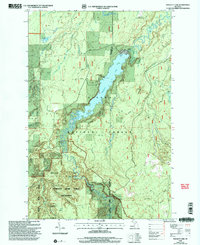
1999 Map of Prickett Lake
USGS Topo · Published 2004About this map
Prickett Lake and the dramatic course of the Sturgeon River anchor this late-twentieth-century topographical study within the Ottawa National Forest. The landscape is defined by the sharp descent of the Sturgeon River Gorge, where the waterway carves through the terrain south of Prickett Dam. This infrastructure, accompanied by a nearby Substation and Gaging Station, indicates the managed use of the river's power. To the west, Silver Mountain rises above the valley, providing a prominent natural landmark near the Sturgeon River Gorge Wilderness.
Find a feature on this map
22 named features on this map. Tap any name to fly to it.
Don’t see what you’re looking for? This feature index may not catch every label — zoom into the map to look around manually.
Map Details
Editions of this 1999 Prickett Lake Map
This is the sole edition of this map. No revisions or reprints were ever made.
Other maps of this area

1954 · Rousseau
USGS Topo · 1:62,500

1954 · Pelkie
USGS Topo · 1:62,500

1954 · Winona
USGS Topo · 1:62,500

1954 · Sidnaw
USGS Topo · 1:62,500

1958 · Iron River
USGS Topo · 1:250,000

1960 · Iron River
USGS Topo · 1:250,000

1961 · Iron River
USGS Topo · 1:250,000

1967 · Iron River
USGS Topo · 1:250,000
1982 · Nisula
USGS Topo · 1:25,000
1982 · Echo Lake
USGS Topo · 1:25,000