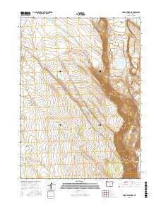
2017 Map of Priday Reservoir
USGS Topo · Published 2017About this map
Warner Valley dominates the eastern landscape of this Lake County region, where the steep escarpment of Lynchs Rim drops toward a chain of high-desert basins. The hydrologic network is the primary feature of this arid terrain, characterized by a series of named water sources essential for livestock and local wildlife. From the larger waters of Hart Lake and Crump Lake to the secluded Ballew Lake, the area is punctuated by specialized features like Sidewinder Waterhole and Boulder Waterhole. The map reveals a land managed for its limited water, with numerous spring-fed sites such as Anthony Springs, Lynch Spring, and Noonan Springs scattered across the sagebrush-covered hills. Cultural modifications like Priday Reservoir and the network of roads, including Plush Adel Rd and Hogback Rd, facilitate movement through the open expanses of Monument Flat and the surrounding high country.
Find a feature on this map
32 named features on this map. Tap any name to fly to it.
Don’t see what you’re looking for? This feature index may not catch every label — zoom into the map to look around manually.
Map Details
Editions of this 2017 Priday Reservoir Map
This is the sole edition of this map. No revisions or reprints were ever made.
Other maps of this area

1955 · Klamath Falls
USGS Topo · 1:250,000

1955 · Adel
USGS Topo · 1:250,000

1957 · Adel
USGS Topo · 1:250,000

1958 · Klamath Falls
USGS Topo · 1:250,000

1958 · Adel
USGS Topo · 1:250,000

1962 · Adel
USGS Topo · 1:250,000

1967 · Plush
USGS Topo · 1:24,000

1967 · Priday Reservoir
USGS Topo · 1:24,000

1967 · Hart Lake
USGS Topo · 1:24,000

1967 · Crump Lake
USGS Topo · 1:24,000