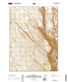
2020 Map of Priday Reservoir
USGS Topo · Published 2020About this map
Warner Valley defines the northeastern portion of this High Desert landscape, where the basin floor meets the steep ascent of Lynchs Rim. This 2020 survey documents a hydrologically sensitive environment where water sources are the primary landmarks. From Priday Reservoir in the north to the edge of Crump Lake in the south, the map is a ledger of essential water points including Ballew Lake and numerous named springs such as Finucane Spring and Antelope Spring. The distribution of these features, along with man-made improvements like the Sidewinder Waterhole and Lassie Waterhole, illustrates the region's historical and ongoing reliance on managed water for ranching. Transportation is sparse, confined largely to routes like Plush Adel Rd and Hogback Rd, which follow the natural contours between the valley floor and elevated plateaus like Monument Flat.
Find a feature on this map
33 named features on this map. Tap any name to fly to it.
Don’t see what you’re looking for? This feature index may not catch every label — zoom into the map to look around manually.
Map Details
Editions of this 2020 Priday Reservoir Map
This is the sole edition of this map. No revisions or reprints were ever made.
Other maps of this area

1955 · Klamath Falls
USGS Topo · 1:250,000

1955 · Adel
USGS Topo · 1:250,000

1957 · Adel
USGS Topo · 1:250,000

1958 · Klamath Falls
USGS Topo · 1:250,000

1958 · Adel
USGS Topo · 1:250,000

1962 · Adel
USGS Topo · 1:250,000

1967 · Plush
USGS Topo · 1:24,000

1967 · Priday Reservoir
USGS Topo · 1:24,000

1967 · Hart Lake
USGS Topo · 1:24,000

1967 · Crump Lake
USGS Topo · 1:24,000