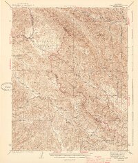
1944 Map of Priest Valley
USGS Topo · Published 1944About this map
Priest Valley and the surrounding high country of the Diablo Range are defined by a complex network of canyons and ridges at the junction of Monterey, Fresno, and San Benito counties. Surveyed in the early 1940s, this landscape shows a sparse but established ranching and mining presence. The southern portion of the map is dominated by the Stone Canyon Mine and the seasonal flows of Slack Canyon and Indian Valley. Educational life in these remote canyons centered on local institutions like the Priest Valley Sch and Wolf Sch. The terrain is characterized by sharp relief, including the jagged formation known as The Pinnacles and various peaks such as Kreyenhagen Pk and Sherman Pk. Significant travel routes followed the natural contours of Peachtree Valley and Monroe Valley, connecting isolated outposts like San Lorenzo (Randall) to larger trade centers outside the quadrangle.
Find a feature on this map
61 named features on this map. Tap any name to fly to it.
Don’t see what you’re looking for? This feature index may not catch every label — zoom into the map to look around manually.
Map Details
Editions of this 1944 Priest Valley Map
2 editions found

Other maps of this area

1912 · Coalinga
USGS Topo · 1:125,000

1914 · Cholame
USGS Topo · 1:125,000

1915 · Priest Valley
USGS Topo · 1:125,000

1915 · Cholame
USGS Topo · 1:125,000

1917 · Cholame
USGS Topo · 1:125,000

1919 · San Miguel
USGS Topo · 1:62,500

1919 · Bradley
USGS Topo · 1:62,500

1941 · Priest Valley
USGS Topo · 1:62,500

1941 · San Ardo
USGS Topo · 1:62,500

1941 · Bradley
USGS Topo · 1:62,500