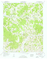
1951 Map of Primm Springs
USGS Topo · Published 1957About this map
Primm Springs serves as a focal point in this mid-century portrait of Middle Tennessee, where the intersection of Hickman, Williamson, and Maury counties reveals a landscape deeply connected to its creeks and hollows. The presence of a dismantled railroad tracking alongside Leipers Creek indicates a shift in the local timber or mineral economy, while abandoned mines near Leatherwood Creek speak to the area's industrial past. This era shows the historic Natchez Trace cutting through the center of the quadrangle, serving as a corridor between small settlements like Kinderhook and Beasley Crossroads. Significant local landmarks, including Johnsons Mill and numerous country churches such as Parham Chapel and Johnson Chapel, reflect a well-established rural community structure. Family history is etched into the terrain through a high density of burial sites, from the Montgomery and Ashworth cemeteries to the Kinderhook Cemetery near the local school.
Find a feature on this map
99 named features on this map. Tap any name to fly to it.
Don’t see what you’re looking for? This feature index may not catch every label — zoom into the map to look around manually.
Map Details
Editions of this 1951 Primm Springs Map
3 editions found
Other maps of this area

1901 · Colombia
USGS Topo · 1:125,000

1936 · Godwin
USGS Topo · 1:24,000

1936 · Williamsport
USGS Topo · 1:24,000

1936 · Primm
USGS Topo · 1:24,000

1936 · Littlelot
USGS Topo · 1:24,000

1936 · Theta
USGS Topo · 1:24,000

1936 · Greenfield Bend
USGS Topo · 1:24,000

1936 · Craigfield
USGS Topo · 1:24,000

1936 · Lyles
USGS Topo · 1:24,000

1940 · Godwin
USGS Topo · 1:24,000