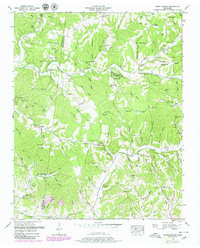
1951 Map of Primm Springs
USGS Topo · Published 1980About this map
Lick Creek and Leipers Creek carve through the dissected plateau of the western Highland Rim, where the borders of Hickman, Williamson, and Maury counties converge. The landscape is defined by its early Tennessee settlement patterns, centered on small crossroads and water-driven industry such as Johnsons Mill. The iconic Natchez Trace cuts through the eastern portion of the map, passing near the old settlement of Kinderhook. Family names are deeply etched into the topography, with dozens of small burial grounds like Montgomery Cem, Slaughter Cem, and Ashworth Cem scattered across the ridges. Higher ground, including Greenbrier Ridge and Lick Ridge, overlooks a network of hollows such as Boneyard Hollow and Shouse Hollow. Educational and spiritual life is marked by the presence of Mt La View Sch and the Fly Ch, anchoring communities that depended on the intricate creek systems for navigation and livelihood.
Find a feature on this map
127 named features on this map. Tap any name to fly to it.
Don’t see what you’re looking for? This feature index may not catch every label — zoom into the map to look around manually.
Map Details
Editions of this 1951 Primm Springs Map
3 editions found
Other maps of this area

1901 · Colombia
USGS Topo · 1:125,000

1936 · Godwin
USGS Topo · 1:24,000

1936 · Williamsport
USGS Topo · 1:24,000

1936 · Primm
USGS Topo · 1:24,000

1936 · Littlelot
USGS Topo · 1:24,000

1936 · Theta
USGS Topo · 1:24,000

1936 · Greenfield Bend
USGS Topo · 1:24,000

1936 · Craigfield
USGS Topo · 1:24,000

1936 · Lyles
USGS Topo · 1:24,000

1940 · Godwin
USGS Topo · 1:24,000