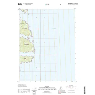
2018 Map of Prince Rupert D-6 SW
USGS Topo · Published 2018About this map
Prince of Wales Island within the southern reaches of the Alexander Archipelago is the primary focus of this 2018 topographic study. Much of the land shown belongs to the Tongass National Forest, illustrating the coastal wilderness characteristic of the Unorganized Borough in Alaska. The intricate coastline is defined by significant waterways such as Kendrick Bay and Gardner Bay. These inlets, along with McLean Arm, provide shelter for marine traffic navigating the winding shoreline. Specific geographical markers like Island Point and McLean Point offer precise navigation points along the jagged edges of the island. Public Land Survey System markers T81s R90e and T82s R90e denote the legal divisions across this largely uninhabited terrain.
Find a feature on this map
11 named features on this map. Tap any name to fly to it.
Don’t see what you’re looking for? This feature index may not catch every label — zoom into the map to look around manually.
Map Details
Editions of this 2018 Prince Rupert D-6 SW Map
This is the sole edition of this map. No revisions or reprints were ever made.
Other maps of this area

1948 · Prince Rupert D-6
USGS Topo · 1:63,360

1948 · Dixon Entrance C-1
USGS Topo · 1:63,360

1948 · Dixon Entrance D-1
USGS Topo · 1:63,360

1951 · Prince Rupert
USGS Topo · 1:250,000

1951 · Dixon Entrance
USGS Topo · 1:250,000

1951 · Prince Rupert D-6
USGS Topo · 1:63,360

1959 · Dixon Entrance
USGS Topo · 1:250,000

1959 · Prince Rupert
USGS Topo · 1:250,000

1964 · Prince Rupert
USGS Topo · 1:250,000
1994 · Dixon Entrance D-1
USGS Topo · 1:63,360