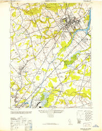
1952 Map of Princeton
USGS Topo · Published 1952About this map
Princeton University and its surrounding academic landscape dominate the northeastern portion of this mid-century New Jersey study. The town’s intellectual character is reinforced by the Princeton Theological Seminary, while institutional reach extends southwest to the Lawrenceville School. Beyond the campus, the map documents a transition from the dense street grids of Princeton to a network of hamlets and crossroads such as Princesville, Franklin Corner, and Slackwood.
Find a feature on this map
66 named features on this map. Tap any name to fly to it.
Don’t see what you’re looking for? This feature index may not catch every label — zoom into the map to look around manually.
Map Details
Editions of this 1952 Princeton Map
This is the sole edition of this map. No revisions or reprints were ever made.
Other maps of this area

1888 · Bordentown
USGS Topo · 1:62,500

1888 · Princeton
USGS Topo · 1:62,500

1890 · Lambertville
USGS Topo · 1:62,500

1890 · Burlington
USGS Topo · 1:62,500

1891 · Lambertville
USGS Topo · 1:62,500

1893 · Bordentown
USGS Topo · 1:62,500

1893 · Burlington
USGS Topo · 1:62,500

1894 · Princeton
USGS Topo · 1:62,500

1894 · Lambertville
USGS Topo · 1:62,500

1904 · Burlington
USGS Topo · 1:62,500