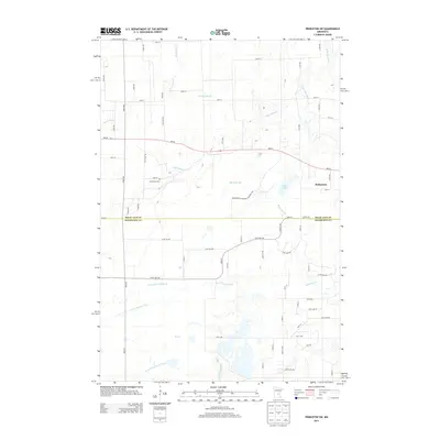
2013 Map of Princeton SW
USGS Topo · Published 2013About this map
The Saint Francis River and its accompanying drainage systems, including County Ditch Number Six and County Ditch Number Three, define the low-lying hydrology of this central Minnesota landscape. Situated on the border between Mille Lacs and Sherburne counties, the area transitions from the more developed western edge of Princeton into a mosaic of wetlands and watercourses. Significant features include Rice Lake and Pool 7, while the northern reaches are marked by the meandering paths of Battle Brook, Prairie Brook, and the W Br Rum River. Local heritage is anchored by the Greenbush Cem, located near the intersection of 20th St and 155th Ave NW. The map's detail reveals an extensive rural road network such as MN-95 and various township roads that navigate around the complex wetlands of the region.
Find a feature on this map
62 named features on this map. Tap any name to fly to it.
Don’t see what you’re looking for? This feature index may not catch every label — zoom into the map to look around manually.
Map Details
Editions of this 2013 Princeton SW Map
This is the sole edition of this map. No revisions or reprints were ever made.
Other maps of this area

1953 · Stillwater
USGS Topo · 1:250,000

1955 · Stillwater
USGS Topo · 1:250,000

1958 · Stillwater
USGS Topo · 1:250,000

1961 · Orrock
USGS Topo · 1:24,000

1961 · Lake Fremont
USGS Topo · 1:24,000

1961 · Becker
USGS Topo · 1:24,000

1961 · Monticello
USGS Topo · 1:62,500

1961 · Elk River
USGS Topo · 1:62,500

1965 · Stillwater
USGS Topo · 1:250,000
1968 · Santiago
USGS Topo · 1:24,000
Featured Places
- Greenbush Township, MN
- Baldwin Township, MN
- Princeton Township, MN
- Blue Hill Township, MN
- Sherburne County, MN