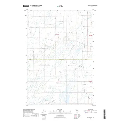
2019 Map of Princeton SW
USGS Topo · Published 2019About this map
Saint Francis River and its associated wetlands dominate this portion of the Minnesota landscape, straddling the line between Mille Lacs and Sherburne counties. The terrain is defined by a dense network of hydrologic features and drainage systems, including County Ditch Number Six, County Ditch Number Three, and Pool 7. These waterways reflect a history of land management and agricultural drainage common to the region's low-lying plains. Settlement patterns are sparse, primarily organized around a rectilinear grid of county roads such as Co RD 7 and Co RD 6. For local historians and genealogists, the Greenbush Cem serves as a primary landmark of the area's early community life. The presence of the Blue Hill Trail in the southern section suggests the area's continued use for recreation and conservation amidst the working landscape of brooks like Prairie Brook and Battle Brook.
Find a feature on this map
83 named features on this map. Tap any name to fly to it.
Don’t see what you’re looking for? This feature index may not catch every label — zoom into the map to look around manually.
Map Details
Editions of this 2019 Princeton SW Map
This is the sole edition of this map. No revisions or reprints were ever made.
Other maps of this area

1953 · Stillwater
USGS Topo · 1:250,000

1955 · Stillwater
USGS Topo · 1:250,000

1958 · Stillwater
USGS Topo · 1:250,000

1961 · Orrock
USGS Topo · 1:24,000

1961 · Lake Fremont
USGS Topo · 1:24,000

1961 · Becker
USGS Topo · 1:24,000

1961 · Monticello
USGS Topo · 1:62,500

1961 · Elk River
USGS Topo · 1:62,500

1965 · Stillwater
USGS Topo · 1:250,000
1968 · Santiago
USGS Topo · 1:24,000
Featured Places
- Greenbush Township, MN
- Baldwin Township, MN
- Princeton Township, MN
- Blue Hill Township, MN
- Sherburne County, MN